
When a forest fire turns into a firestorm
On the formation of one of the largest pyrocumulonimbus clouds over Europe to date: The story of extreme fire-driven convection leads to a meteorological first for France.
In the summer of 2026, France was confronted with a phenomenon previously known primarily from Australia, North America, and Siberia: a massive pyrocumulonimbus cloud—internationally referred to as PyroCb and meteorologically classified as *Cumulonimbus flammagenitus*.
Above an extremely intense forest fire in southwestern France, a distinct thunderstorm cloud formed from a rising column of smoke and heat. The fire front was thus no longer merely generating heat and smoke but had begun to create its own local weather system. French emergency responders described the event as unprecedented in the country.
A pyrocumulonimbus cloud forms when a fire releases enough energy to cause hot air to rise at tremendous speed. Within this massive convection column, smoke particles, water vapor, and combustion products are carried kilometers high. When the rising air reaches sufficiently cold layers of the atmosphere, the water vapor condenses to form a thunderstorm cloud.
The result is a paradoxical phenomenon: the fire generates a thunderstorm, and the thunderstorm, in turn, can intensify the fire. Through strong downdrafts, dry katabatic winds, and its own lightning discharges, a pyrocumulonimbus cloud can spark new fires and make the spread of a fire more unpredictable.
Hiroshima 1945: One of the earliest documented fire clouds
One of the most famous historical fire clouds was created following the dropping of the atomic bomb on Hiroshima, Japan, on August 6, 1945. The explosion initially generated extreme thermal radiation. Temperatures in the immediate vicinity of the blast center reached several thousand degrees Celsius. Thousands of buildings made of wood and paper ignited almost simultaneously.
A massive, rising column of hot air, smoke, and ash formed over the city. This phenomenon resembled a fire-induced convection cloud—an early form of what is known today as a pyrocumulus or pyrocumulonimbus cloud.
The decisive factor was the enormous simultaneous release of thermal energy.
Incendiary bombs and the development of firestorms in wars
Incendiary weapons designed to create large-scale fires were developed during the 20th century. Entire cities were subjected to incendiary bomb attacks, particularly during World War II. These attacks employed, among other things, incendiary agents that promoted the spread of massive fires. However, the extreme firestorms that devastated Hamburg in 1943, Dresden in 1945, and Tokyo in 1945 were not caused solely by the incendiary materials themselves; rather, they resulted from a combination of factors: a vast number of buildings burning simultaneously, dense urban development, the influx of oxygen driven by powerful updrafts, and the release of immense heat.
Well-known major events
- Bombing of Hamburg ("Operation Gomorrah", 1943): created one of the most well-known firestorms of the Second World War.
- Bombing of Dresden (1945): A combination of high-explosive and incendiary bombs resulted in a devastating firestorm.
- Bombing of Tokyo (1945): large-scale use of incendiary bombs against a city built predominantly of wood.
In physical terms, the principle resembles modern mega-fires: once a burning area crosses a critical energy threshold, it can develop its own dynamics.
Pyrocumulonimbus events of the last 20 years
Canada 2023
The 2023 wildfire season was extraordinary. Scientific analyses report approximately 140 observed pyrocumulonimbus events in Canada, accounting for the majority of the PyroCb activity recorded worldwide that year.
Australia – Black Summer 2019/2020
The Australian bushfires are considered one of the most extreme pyrocumulonimbus events of the modern satellite era. During the 2019/2020 fire season, 35 PyroCb clouds were observed. More than half of the documented fire-induced thunderstorms transported smoke particles directly into the stratosphere.
Particularly extraordinary:
- Smoke was transported to an altitude of about 35 kilometers.
- A massive plume of smoke circled parts of the Southern Hemisphere.
- Distinct atmospheric structures emerged.
Sichuan, China, 2020 and 2022
According to Chinese weather agencies, the wildfires have generated PyroCb clouds reaching altitudes of up to 14 kilometers.
California 2018–2020
Several major fires in California generated pyrocumulonimbus clouds:
- Carr Fire (2018)
- Mendocino Complex Fire (2018)
- Creek Fire (2020)
During the 2020 Creek Fire, a particularly impressive fire cloud formed, characterized by extreme updrafts and dangerous shifts in the wind.
Canada, British Columbia 2017
The 2017 Canadian wildfire season produced some of the most intense PyroCb events on record. The fires were so intense that smoke and heat were transported to high altitudes. These events were later compared to the 2019–2020 Australian fires.
Black Saturday, Victoria, Australia 2009
Extreme bushfires generated massive PyroCb towers that released so much energy that they dominated weather patterns over hundreds of kilometers.
Events since the 1980s
May 8, 1987: "Great China Fire", Northern Mongolia, China
Sep 10, 1988: Yellowstone National Park, Wyoming, USA
June 21, 1991: Baie-Comeau Fire, Quebec, Canada
June 21, 1991: Baie-Comea5. Aug 1998: Norman Wells, Northwest Territories, Kanonau Fire, Quebec, Canada
Sep 27, 1998: Khabarovsk, Russia
Aug 23, 1998: Khabarovsk, Russia
Aug 27, 2000: Jasper Fire, Black Hills National Forest, South Dakota, USA
August 19, 2000: Idaho, USA
May 29, 2001: Chisholm Fire, Alberta, Canada
June 10 – 19, 2002: Hayman Fire, Colorado, USA
June 20, 2002: Rodeo-Chediski Fire, Arizona, USA
Dec. 18, 2002: Victoria, Australia – Big Desert Wilderness Park
Jan. 27, 2003*: Southeastern Australia
1 Feb 2003: Southeastern Australia
Jan. 19, 2003: Canberra bushfires, Australia – generated an F3 fire tornado
May 4–6, 2003: Eastern Russia
Aug 18, 2003: Conibear Lake Fire, Wood Buffalo National Park, Canada
There was hardly any systematic satellite observation prior to 1987. The best-known early event is Hiroshima in 1945. There has been a sharp increase, particularly since 2002.
The Guinness Record:
The highest number of PyroCbs in a single summer occurred in the USA and Canada in 2002.
They are triggered by large forest fires, volcanic eruptions, and firestorms caused by nuclear explosions. Scientific study of these phenomena has only taken place over the last 20 years, which is why the list of events prior to 2000 is short. Since Australia’s “Black Summer” of 2019/20, however, they have been monitored more closely worldwide. Until 2010, data on many fires in Asia was not included in Western satellite databases such as TOMS or SAGE II; China itself has only been publishing PyroCb data for a few years.
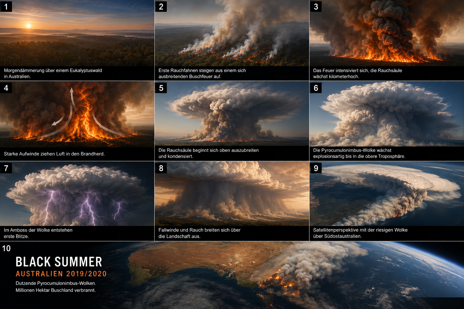
- From Bushfire to Pyrocumulonimbus Cloud
A New Era of Fire Dynamics
The increasing frequency of extreme pyrocumulonimbus events reveals a new dimension of modern large-scale wildfires. Many such events form and dissipate within just a few hours. Satellite observations from recent decades have, for the first time, enabled the systematic tracking of these fire-driven thunderstorms. A global inventory compiled since 2013 highlights the growing significance of this extreme coupling between fire and the atmosphere.
Researchers have calculated that the wildfires raging in central Spain in the summer of 2026 released thermal energy equivalent to that of 28 Hiroshima atomic bombs. However, no pyrocumulonimbus cloud formed there.
A pyrocumulonimbus cloud is no ordinary smoke plume. It is a sign that a fire has reached a scale where it interacts with the atmosphere. The fire ceases to merely destroy the landscape; it begins to generate its own weather.
The largest forest fires in France in the last 20 years
The most devastating fires were concentrated in the drought years of 2022, 2025, and the current record year of 2026:
- The fires in the Gironde department (July 2026): Driven by extreme heatwaves, the most devastating "mega-fire" in recent history raged near the Atlantic coast, southwest of Bordeaux. More than 42,000 hectares of forest burned in a single week. Tens of thousands of people had to be evacuated.
- The fire in the Corbières (August 2025): A massive fire in southern France destroyed more than 16,000 hectares region. At the time, the authorities described it as the most severe single fire incident since 1949.
- The Landiras and La Teste-de-Buch fires (summer 2022): Also in the heavily wooded Gironde region, just under 30,000 hectares burned in major fires. The fire in Landiras covered an area of 12,500 hectares.
- The Gonfaron / Massif des Maures Fire (August 2021): In the hinterland of the Côte d’Azur, in the Var department, a devastating fire destroyed around 7,000 hectares. valuable natural and forest areas.
A new all-time record
The year 2026 shattered all previous satellite measurement records. Due to extreme heat and dry soil conditions, around 100,000 hectares in France had already burned by the end of July 2026. area. This significantly exceeds the previous record year of 2022—which was already catastrophic (approx. 72,000 hectares)—and amounts to more than five times the long-term 20-year average.
The average annual temperature in France has risen by just under 1.1 degrees Celsius over the past 20 to 25 years (with a long-term warming rate of approximately 0.46 degrees Celsius per decade).
Data from the national weather service Météo-France show that this trend has accelerated dramatically, particularly in recent decades. France is warming about 30 percent faster than the global average. The years 2022 and 2023 were among the warmest on record, followed by a heatwave of historic intensity in the summer of 2026 that set new temperature records across the country.
That during the massive fire in the Gironde in France in July 2026, for the very first time ever the phenomenon of a pyrocumulonimbus cloud (PyroCb) occurred, that is likely because extremely rare, absolutely extraordinary conditions have to coincide. Normale Waldbrände erzeugen zwar oft kleinere Rauchwolken (Pyrocumulus), aber für ein echtes, kilometerhohes „Feuergewitter“ (Pyrocumulonimbus) müssen physikalische Grenzwerte überschritten werden, die in Westeuropa historisch bisher nur nach dem Einsatz von Brandbomben um 1945 erreicht wurden.
Images: AI-generated reproductions of a pyrocumulonimbus cloud over the 2019/20 Australian bushfire.